China’s new satellite to help predict earthquakes
Beijing. February 7. Silkroadnews - A new Chinese satellite will help predict earthquakes, the Global Times reports.
“China launched its first seismo-electromagnetic satellite to study seismic precursors, which could help establish a ground-space earthquake monitoring and forecasting network in the future,” the report said.
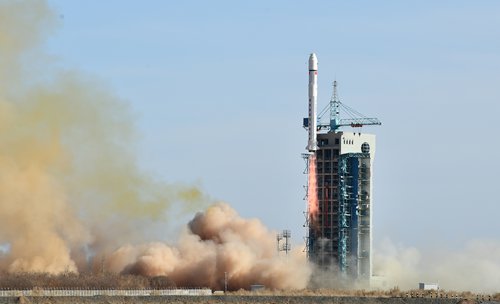
A Long March-2D rocket carried out the 730-kilogram China Seismo-Electromagnetic Satellite (CSES) Zhangheng 1 into a sun-synchronous orbit at an altitude of about 500 kilometers. According to Zhao Jian, a senior official of China National Space Administration (CNSA), the satellite is expected to operate for five years.
Zhangheng 1 will record electromagnetic data related to earthquakes above 6 magnitude in China and those that exceed 7 magnitude around the world to identify patterns of electromagnetic disturbances in the near-Earth environment.
The satellite will focus on the mainland of China, within 1,000 kilometers of China’s land borders and two major earthquake belts.
Research revealed that immediately before the earthquake tectonic forces acting on the Earth’s crust emit electromagnetic waves and twist the lines of magnetic fields. But such phenomena are relatively weak and require further study.
Zhangheng 1 will run in-orbit tests for about six months to assess its data quality before it is formally put into service. A second seismo-electromagnetic satellite is under evaluation, the agency reports referring to Zhao Jian, the senior official with CNSA. The satellite will also provide data services for weather forecasts, aerospace and navigation communications, space physics and geophysics research.


